


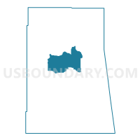
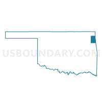
Voting District 14, Delaware County, Oklahoma
About
Outline

Summary
| Unique Area Identifier | 653944 |
| Name | Voting District 14 |
| County | Delaware County |
| State | Oklahoma |
| Area (square miles) | 43.33 |
| Land Area (square miles) | 43.33 |
| Water Area (square miles) | 0.01 |
| % of Land Area | 99.98 |
| % of Water Area | 0.02 |
| Latitude of the Internal Point | 36.45438510 |
| Longtitude of the Internal Point | -94.80121530 |
Maps

Graphs
Select a template below for downloading or customizing gragh for Voting District 14, Delaware County, Oklahoma


Neighbors
Neighoring Voting District (by Name) Neighboring Voting District on the Map
- Voting District 12, Delaware County, OK
- Voting District 15, Delaware County, OK
- Voting District 16, Delaware County, OK
- Voting District 17, Delaware County, OK
- Voting District 18, Delaware County, OK
- Voting District 8, Delaware County, OK
- Voting District 9, Delaware County, OK
Top 10 Neighboring County Subdivision (by Population) Neighboring County Subdivision on the Map
Top 10 Neighboring Place (by Population) Neighboring Place on the Map
- Jay city, OK (2,448)
- New Eucha CDP, OK (405)
- Sycamore CDP, OK (177)
- Drowning Creek CDP, OK (155)
- Deer Lick CDP, OK (46)
- Brush Creek CDP, OK (35)
Top 10 Neighboring Unified School District (by Population) Neighboring Unified School District on the Map
Top 10 Neighboring State Legislative District Lower Chamber (by Population) Neighboring State Legislative District Lower Chamber on the Map
Top 10 Neighboring State Legislative District Upper Chamber (by Population) Neighboring State Legislative District Upper Chamber on the Map
Top 10 Neighboring 111th Congressional District (by Population) Neighboring 111th Congressional District on the Map
Top 10 Neighboring Census Tract (by Population) Neighboring Census Tract on the Map
- Census Tract 3760, Delaware County, OK (5,542)
- Census Tract 3759, Delaware County, OK (4,144)
- Census Tract 3756.01, Delaware County, OK (3,303)